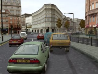
 According to Isaac Levanon, top dog at 3D imaging firm 3DVU, in-car satellite navigation will soon include realistic renderings of the buildings and other landmarks that line roads.
The technology is not too much of a stretch beyond the current scrolling schematics that can be found in devices from firms like Garmin and TomTom. Indeed, graphics good enough to recognise most of the streets in Central London were crammed onto a single CD - along with a rather nasty video game - for 2002’s PlayStation 2 shoot-fest, The Getaway (pictured above - imagine a big green arrow instead of the cars and you can imagine what a future satnav screen might look like).
Apparently various German, South Korean, Japanese and
Somewhat oddly, Levanon argues that adoption of 3D navigation applications will be driven by manufacturers' desire for differentiation, not demand from paying customers. Auto IT would beg to differ. Particularly in city centres, it’s all too easy to take a wrong turning when street intersections are only yards from each other. Pictures of the buildings would clearly help drivers to pick out the correct route.
In the longer term, head-up displays that paint translucent arrows or other visual indicators on the windscreen, overlaying the actual view of the road seen by the driver, seem like the optimum solution for getting where you want to go without confusion.


